When Michael Imperiale moved to Michigan from Brooklyn, New York, he noticed the mile road system and wanted to know what it was all about.
"I've asked people from time to time, occasionally, and no one seemed to know," Imperiale said. He's a professor of microbiology and immunology at the University of Michigan.
Asking his friends was a dead end, but that didn't stop Imperiale's curiosity. He took to MI Curious and asked a simple question: 8 Mile is 8 miles from where?
(Support trusted journalism like this in Michigan. Give what you can here.)
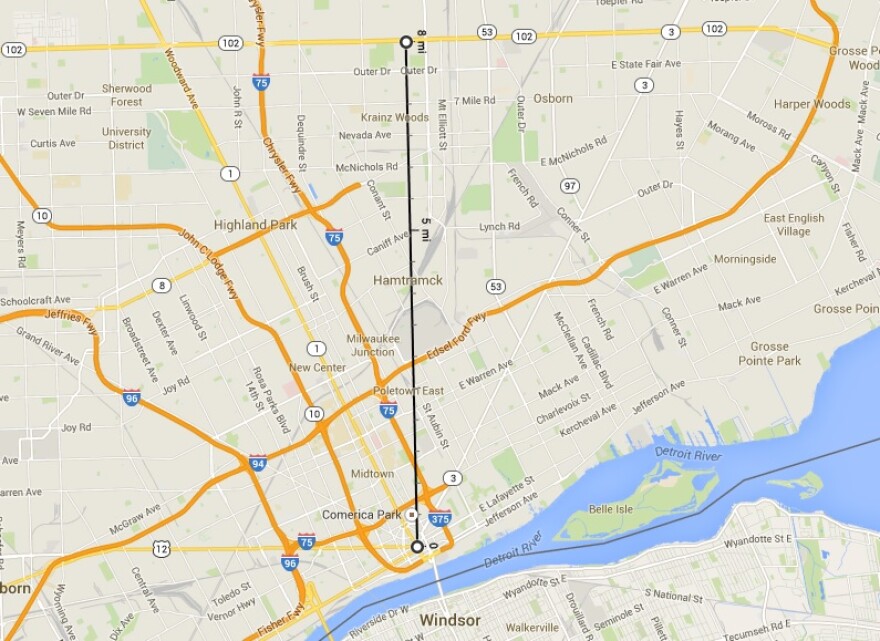
To some it might seem obvious – 8 Mile Road is eight miles from Detroit's riverfront, right?
Wrong.
So where does the mile road system start? Where is mile zero? Why aren't miles one through six called One through Six Mile in Detroit?
The answer is deeply rooted in Detroit's history, before the French and the British. It began with the Native Americans and the trails that crisscrossed where some of Detroit's roads stand today.
The answer is deeply rooted in Detroit's history, before the French and the British. It began with the Native Americans and the trails that crisscrossed where some of Detroit's roads stand today.
The spoke-wheel layout of Detroit's streets is often attributed to Judge Augustus Woodward. But according to Joel Stone, senior curator at the Detroit Historical Society, that's a common misconception.
"The spoke-wheel plan we can attribute to the Native Americans," Stone explained. "They were here long before anyone else, and they had established trails."
These trails would take them down to Toledo, up to Port Huron, off to Grand Rapids, or up towards Pontiac. They were used for trade and travel and still stand today, just with different names than they once had: Jefferson, Gratiot, Woodward, Grand River, Michigan Avenue, and Fort Street.
The streets are the major spokes of Detroit's wheel system and their hub is Campus Martius Park.
When Detroit was settled, Campus Martius was deemed the center of town because it was where all of these main roads came together. It was the location of the first train station, city hall, and was deemed the starting point for the state's mile road system.

Because Campus Martius is on an angle, and Woodward Avenue is too, the mile roads are counted directly north from the park, and the roads run east and west. That makes Michigan Avenue "zero mile," and of course 8 Mile Road is eight miles away.
It would seem as though the eighth-mile away wouldn't carry as much significance as the 8 Mile that exists today, so when and why did the road start to matter?
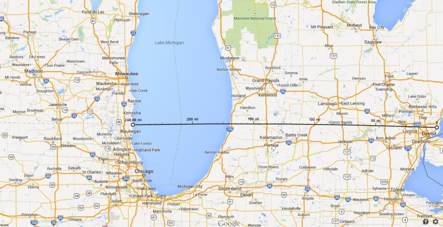
Once established, 8 Mile Road served as the baseline for determining the upper and lower boundaries of counties across the southern section of the state. As shown here, it can be traced all the way to Lake Michigan, where it is appropriately called "Baseline Road."

"8 Mile road is most important, in fact, important to Detroit and all of Michigan." Stone said.
But Stone explains that the road also dictated way more than just mapping in Michigan – in fact, 8 Mile Road can be traced all the way across Lake Michigan to Illinois and Wisconsin, where it almost lines up with the dividing line between the two states.
"Not exactly," Stone said. "It's off by just a little bit, but I imagine that had to do with the early transit equipment that they had to do the surveying with, but that 8 Mile was an important line for the whole Northwest, all the way across."

In addition to serving as the defining line for surveying, 8 Mile has an immense cultural significance as well. It serves as a racial divide between the city of Detroit and its suburbs.
Though it is common for major metropolitan areas to have divisions by race, as exhibited bythis article by Al Jazeera, few cities show such an obvious border as Detroit does.
Surprisingly, 8 Mile dictates a lot in our state, and in the Midwest. "8 Mile is eight miles from where?'"seemed like a simple-enough question, but 8 Mile is no simple road. Though it was rather arbitrary for urban planners to put so much weight on the eighth-mile away from Campus Martius, the road really defines our state culturally and physically, and its impact spans all the way across Lake Michigan.
It's no wonder that Michael Imperiale's friends didn't have the answer – we were surprised by it ourselves.
– Paige Pfleger, Michigan Radio Newsroom
*Clarification - An earlier version of this post asked "Why aren't miles one through six called One through Six Mile?" The question focused on streets in Detroit. It's been clarified above.


